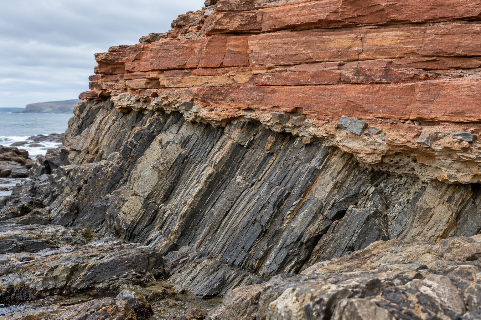
At Siccar Point on the Scottish coast, dark beds of sandstone and shale stand steeply tilted beneath much flatter red rock. The eye follows one set of lines toward the other and finds that the dark beds simply stop. Between them lies a boundary you could cross in a step. The history required to make it cannot be crossed so quickly.
The dark sediment first accumulated in an ancient sea. It became rock, was folded and raised, and then lost its upper part to erosion. Only after that did sediment from rivers spread across the worn surface and become the red beds above. The 1992 geological survey of Siccar Point records the older beds' tight folds, their truncated ends and fragments of them in the younger breccia. Those fragments are especially useful. They show that the older rock was exposed and broken before the newer deposit enclosed its pieces.
This boundary is an unconformity: a contact across which the local rock record skips an interval. The word names a relationship, not a particular number of missing years. Some sediment may never have accumulated at this place. Some may have formed and later been stripped away. Often both happened at different times. The rock above resumes the story only when deposition began again and enough of that deposit survived.
A line made by several events
At Siccar Point the difference in angle makes the interruption conspicuous. Geologists call it an angular unconformity. The field guide by Brian Turner and Colin Scrutton describes near-vertical Silurian greywacke below gently dipping red breccia and sandstone. It also reports marine fossils in shale near the site and sedimentary structures in the younger red beds consistent with river deposition. Those clues do more than identify two colours of stone: they place the rocks in different environments on opposite sides of the break.
The older beds had to exist before they could be folded. Folding had to precede the erosion that cut across their tilted ends. Erosion had to expose the fragments before the red sediment could contain them. The contact therefore orders events even where it does not preserve a layer for each one. It is tempting to picture a single immense storm carving the surface. Nothing about an angular contact by itself requires that. Uplift, weathering, erosion, pauses and renewed deposition may occupy much of the interval.
The visible geometry also does not supply a stopwatch. The field guide estimates about 20 million years missing at Siccar Point; a 2016 Geological Society of Glasgow account puts the gap at roughly 60 million. Neither number can be read off the angle. What the outcrop makes plain is the sequence: marine sediment, deformation, exposure and erosion, then terrestrial sediment. Assigning a duration takes evidence beyond the shape of the junction.
The quiet gaps
Other breaks are harder to see because the beds above and below remain nearly parallel. These are disconformities. A walker might see an ordinary stack of limestone and sandstone where a geologist sees a long pause. At Grand Canyon, the National Park Service's account of missing time describes a flat-looking contact beneath the Redwall Limestone. Fossils on its two sides reveal a gap of about 150 million years that would be difficult to recognize from the bedding alone. In another canyon exposure, a thin pebble-rich layer helps show where erosion interrupted deposition. The clues differ; the missing interval is inferred by putting them together.
The same account distinguishes a nonconformity, where younger sedimentary rock rests on older igneous or metamorphic basement. These labels describe the rocks and geometry at a contact. They do not measure its duration. A steep angular break can represent less time than a nearly level one; a dramatic photograph cannot tell you which gap is longer.
Grand Canyon makes the local nature of the answer unusually clear. Where its younger Paleozoic layers rest directly on the Vishnu basement rocks, the National Park Service estimates roughly 1.2 billion years unrepresented at that contact. Nearby, remnants of the Grand Canyon Supergroup lie between basement and Paleozoic rock. At one illustrated place, the older contact below the Supergroup skips up to about 500 million years, while the angular contact above it skips roughly 590 to 740 million. The numbers depend on the rocks actually touching at each site. A missing interval at one ledge may be partly preserved around the bend.
How to put ages on absence
Geologists begin with the rocks that survived on either side. A fossil assemblage can show that a younger community lies above an older one with expected intervals absent between them. Datable minerals can narrow the age of a bed or of events in the surrounding rock. But an age from a grain does not automatically date the day its host sediment was laid down. A grain can be older than the sand that carried it.
That distinction mattered in a 2018 study of the Grand Canyon region. Karl Karlstrom and colleagues dated detrital zircon grains from units around the Great Unconformity. The youngest grains gave maximum depositional ages: a sandstone containing one of those grains must be no older than the grain, but it could be younger. Combined with calibrated trilobite zones, the results placed a major marine advance across the region at about 505 to 500 million years ago. The authors also found that the Sixtymile Formation, once treated as Precambrian, held younger Cambrian evidence. Better dates can change which rocks belong below a gap, and therefore change how the gap is described.
The missing interval is not wholly beyond investigation. Minerals beneath an unconformity can retain traces of cooling as buried rock was brought closer to the surface. In an original zircon study from eastern Grand Canyon, Olivia Thurston and colleagues modeled a major phase of basement cooling around 1,300 to 1,250 million years ago. They also state a limit: their zircon data are relatively insensitive to some later stages of unroofing before the Cambrian cover arrived. A cooling history helps locate parts of the process; it is not a complete film of everything that happened on the exposed land.
Nor should a familiar name make every distant contact one synchronized event. C. P. Sturrock and colleagues' 2021 study used apatite data and thermal-history models beneath the Great Unconformity in the central Canadian Shield. Their results point to more than three kilometres of erosion between about 650 and 440 million years ago across their study area. That later history differs from the major older cooling inferred in eastern Grand Canyon. The methods carry uncertainties, and cooling requires geological context to interpret as erosion, but the comparison cautions against treating the continent's various exposed surfaces as one cut made everywhere at once.
An unconformity is thus both a loss and a useful remnant. The vanished sediment cannot be read where it vanished. Yet the angle of the beds, a broken clast in the first new layer, a fossil change, or a mineral's cooling history can constrain what the blank interval contained. The most honest question at a rock boundary is specific: which years are absent here, and which marks at this contact allow us to say so?
A thought worth keeping?